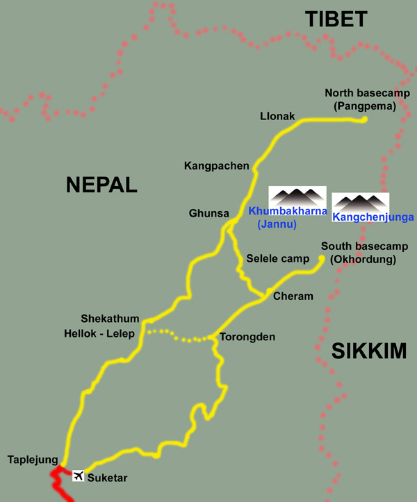
Kangchenjunga Trek
These notes have been updated following our third visit to the area in November 2023, from south to north base camp since that is how we did it. There are many more lodges and other changes. We think this is probably the best lodge trek left in Nepal, given the intrusion of roads and hydro works into so many other trekking areas. And change is coming fast here too - there will be a road to Ghunsa within two years.
The north then south tracknotes have not been updated so use the South then North tracknotes in reverse!
In 2012, on our first visit, there was no reliable information on whether the north and south sides of Mt Kangchenjunga could be visited as a lodge trek. The answer we found was definitely yes, in season, and these track notes are offered as a guide for those interested.The notes have been viewed more than 25,000 times.
Our reason for providing track notes is to increase the flow of money direct to locals, who tell us that “teahouse trekking is best”, a force for positive local development better than the tented expeditions which carry all their supplies from Kathmandu.
Since these notes were first published in January 2013 (and viewed 25,000 times!), trekking numbers on both sides have increased markedly, which has already resulted in more rooms and improved lodges and a higher standard of living for locals. Numbers continue to increase, with many camping groups in October 2023, but it is as nothing compared to the Khumbu which sees more than 30,000 trekkers per month at peak. Kangchenjunga still sees less than 1000 trekkers all season (2019 figures).

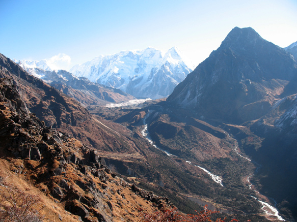
Kangchenjunga (Kang-chen-dzo-nga, meaning 'The Five Sacred Treasuries of the Snows') is the third highest mountain in the world at 8586m and difficult to access as it is located along the north-eastern border of Nepal with Sikkim (India) and Tibet. The area is also relatively undeveloped so trekking is seasonal. The usual trekking destinations are the climbing base camps and viewpoints on the south and north sides of this massive mountain. We found that the traverse between these was also highly enjoyable, making for a very satisfying and wild experience.
Don’t expect the formed tracks of the Everest and Annapurna regions, although tracks are being rapidly improved up the north side. If you are grateful for a stone hut, wooden bed, evening dalbhat and daily wilderness, you will greatly enjoy this remote trek. Even today, only about 1,000 trekkers a year visit this place compared to over 90,000 in the Khumbu, so it is possible to walk blissfully all day and see nobody else. Most people you will meet will be in camping groups but you will also meet some independent trekkers with their guides and/or porters. Note that there is considerable exposure on many of the tracks, so don’t go if you have vertigo or a fear of heights.
This matrilineal Limbu ('the bearer of bows and arrows’) homeland is not highly populated, particularly on the south side, and the people follow animist, Buddhist and some Hindu beliefs. Phale and Ghunsa on the northern side are uniquely Tibetan in architecture and religious practice but we were surprised by the general lack of outward religious signs that characterise the Khumbu region, for instance. There is a focus on tongba, warm millet beer served in brass-decorated wooden pots with a straw.
The trek around Kangchenjunga can be done entirely as a lodge trek in September-October-November and in March-April-May. At the start and end of these periods there may be some lodges closed, particularly at higher altitudes. Always enquire before relying on these notes.
There are toilets in nearly all places and phone access, limited on the south side. There is mobile reception (but not NCELL) on most of the north side and at the start of the south side.
My wife and I trekked the south-to-north route described below in October-November 2012 with a good friend from Germany and the north-to-south route in November-December 2013. The weather was superb both times. The first time we did 16 (should have been 17) days actual walking including some long days, plus 2 rest days and 4 days for travel to and from the walk. So we were 22 days from Kathmandu but had allowed some extra days for illness and bad weather if needed. The second time, due to strikes, we had to walk in from the airstrip at Tumlingtar, which required an extra 4 walking days and led logically to the north-to-south route, taking 18 walking days with no rest days. We were 26 days from Kathmandu. In 2023 we returned and trekked in November to south then north base camp and allowed 24 days actual trekking for side-trips as well, plus 2 days at each end for transit. The weather at the start was cloudy every afternoon as the monsoon gets later each year, but by mid-November days were clear and definitely colder.
We have now trekked Kangchenjunga south-to-north and north-to-south and these track notes separately cover both directions. However on balance we would definitely choose to trek to the southern side first, then cross to the northern side and exit down that valley. Some people regard the steep climb above Cheram as being a show-stopper, but these people generally came DOWN this climb. It is probably easier to climb than descend. If you climb it, then within 2-3hrs the day’s climbing is over and you can enjoy the most marvellous traverse. Some people who had descended to Cheram chose not to go up to the south base camp because they were too tired, which is a great pity – another reason to trek south then north! An alternative view is that north-to-south is better for acclimatisation, if that is a known issue. More details below.
We hope that these track notes will make this trek more popular and so improve the lives of villagers and the number and standard of the lodges. It is a great and memorable trek that we hope you will enjoy.
We are glad too that the aspiration of the World Wildlife Fund to build a luxury lodge near Khampachen and to 'discourage' lodge and teahouse trekking was not realised. More information
A special Restricted Area permit is required for Kangchenjunga. These permits require that you have a registered guide and a party of two or more. The fee is $US60 per person payable in Kathmandu plus the Kangchenjunga Conservation Area (KCA) entry fee of $US20 per person, which can be paid on the walk. Unless you are continuing to the Khumbu (which is a great trip if you have the time), the Restricted Area permit means that you do not need a TIMS card (Trekkers Information Management System) as well. You will need 2 photos per person for the permit.
To get a good view of the culture we recommend finding a guide who speaks Tibetan and Nepali as well as your native tongue.
We very highly recommend Visit Himalaya Treks
In 2022 we used the updated Nepal Maphouse Kanchenjunga Region 1:100,000 map and found it mostly accurate. The spelling of place names from this map have mostly been used in the following track notes but alternate spellings are given. We have also consulted Kev Reynolds’ 1999 Cicerone Guide to Kangchenjunga, which out-of-date regarding tracks but contains a lot of interesting local and historical information.There is a link to the Alpine Club journal report of the first 1955 ascent of Kangchenjunga at the bottom of this interesting article https://www.thebmc.co.uk/kanchenjunga-8586m-the-story-of-the-first-ascent
Lodges vary and menus are now more widely available, there are even hot showers in Ghunsa. You can certainly raise dalbhat, tsampa, noodles, omelette and roti at most places, but coffee is sometimes scarce and you may want to take your own. There are still few shops and often stocks are limited to noodles, biscuits, toilet paper, tobacco and alcohol. Water, batteries and soap are not always available. Porridge, muesli and pancakes are arriving on the repertoire of many kitchens.
· Two complete sets of track notes are given: going to the south side and then to the north side, and going to the north side and then to the south side.
· Track times given are actual hours walking, with brief rests. The times do not include lunch, for instance, which may add two hours if you are ordering dalbhat. This can be an issue: your guide and porter expect to eat at 10am or 11am depending on how early you start and often they use this waiting-for-lunch time to wash themselves and clothes. Our solution is to make a rule to walk for at least 3 hrs before stopping, which makes sure some good progress is made and then feel happy about a long lunch. Following complaints that our track times are too short, they have been adjusted in the following update.
· Lodges we know have ** in the notes following. Room rate is given as (Rs300) where known and (db Rs250) gives the dalbhat price, a sort of Big Mac index for Nepal.
· Altitudes are from the map, in metres. Height gain/loss per day is cumulative and rough, from a cheap altimeter but may help you know what is coming. Net gain/loss can be derived by looking at the start and finish altitudes each day.
· Villages in bold in the following tables are the stages described, but of course you can vary these stages depending on fitness and availability of accommodation.
There are four ways to start and finish these treks. A guide may now be required for these access and exit routes and there is a myriad of tracks and very few people to ask if you get off route. Usually your guide will come from Kathmandu since local guides are an unknown quantity at this time.
The following table allows you to estimate itinerary lengths using various access and exit options.
|
Trek |
*Access/exit route |
*Days for access or exit |
Plus days for trek |
|
South to north |
Bhadrapur - Suketar/Taplejung |
2 |
18 |
|
|
Basantpur - Suketar |
4 |
18 |
|
|
Tumlingtar - Suketar |
6 |
18 |
|
|
Biratnagar-Suketar |
Not currently available |
18 |
|
North to south |
Bhadrapur - Taplejung/Suketar |
2 |
18 |
|
|
Basantpur - Dobhan |
3 |
18 |
|
|
Tumlingtar - Dobhan |
5 |
18 |
|
|
Biratnagar - Suketar |
Not currently available |
18 |
*from and to Kathmandu
· Fly Kathmandu-Bhadrapur, minibus to Fikkal, then bus/jeep to Taplejung/Suketar. This alternative is best for south to north as it is fastest and cheapest in our opinion and could be used also for north to south with an extra day’s walk down to Mitlung. Nepal Airlines is scheduled to fly direct to Kathmandu to Suketar but is so often cancelled by clouds and other issues it is not worth considering.
o Kathmandu to Fikkal (flight/minibus) 4-5hrs
There are multiple daily flights to this quiet and charming area of coconut palms and rice on the eastern Nepal border with India. We took a Buddha Air flight at 1350hrs for $US254 (2023) each, then a minibus for 1.5 hrs from the airport on uncrowded asphalt roads through teak forests up to the pleasant **Kanyam Inn 9844.643.720 / 9817.930.905 (Rs1300 modern room with hot shower, db Rs400) 3km before Fikkal (1468m) looking over tea plantations, lovely cloudscapes and the Kangchenjunga massif. There are several good hotels in Fikkal itself as well, some located in tea plantations.
o Fikkal to Suketar (jeep/bus) 9-10hrs
Local buses are available in Fikkal itself but we organised a comfortable 4WD ($US220-250 one-way) and enjoyed the quality but endlessly twisting road, passing through the major tea-producing town of Ilam (800m, tea and cardamom elanchai are grown extensively here) after 4hrs, from which you can access Darjeeling, and then Phiddim (1038m) for lunch. The road goes as low as a hot 800m and as high as a cool 2300m. The district headquarter of Taplejung (1870m; ‘fort of King Taple’) was reached after 8-9hrs. You can walk up to the airstrip at Suketar (2420m) in 1.5hrs or take a jeep for Rs100. **Hotel Everest View (Rs2500, db Rs400) adjoins the airstrip; Hotel Yak opposite might be a better choice.
· Fly or bus Kathmandu-Biratnagar and take a 5-6hr bus trip to Basantpur then walk to Dobhan (2 days) or Taplejung/Suketar (3 days). There are multiple daily flights to Biratnagar and it is possible to connect with a bus to arrive in Basantpur the same day. There is also a very long bus ride direct to Basantpur. Some of the teahouse trekkers we met had used this access route but thought the bus trip was hard. The route, the first day of which we have yet to walk, is as follows:
o Basantpur (2310m) - Chauki (2660m) – Mangelbari (2620m) – Gupha Pokhari (2870m) 20km, 1000m↑ 240m↓ 6-7hrs
o Gupha Pokhari (2870m) – Gurja (1925m) – Dobhan (640m) 2200m↓ 7 hrs – details under Tumlingtar below.
o Requires one more day’s walk to Taplejung and Suketar but you may get a jeep.
· Fly Kathmandu-Tumlingtar, walk for 4 days to Dobhan or 5 days to Taplejung There are daily flights to Tumlingtar (324m) (eg Yeti at 1115h, 35mins, $US137 (2017) plus departure tax $US2). We consider it worth staying overnight in Tumlingtar and starting the walk the next day as it can be hot climbing to the first alternative accommodation. The pleasant **Arun Hotel may now be closed but Makalu and Kangchenjunga hotel opposite airport entrance are also available. The walking route is as follows:
o Tumlingtar to Chainpur 230m↓ 900m↑ 6-7h
Walk south on the new tarmac road and drop 100m to vehicle bridge over the Sabha Khola after 1hr, climb steeply on shortcut immediately left after bridge, crossing the road several times and walking along it at times, passing Gahati and Gairigaon. At 5 wooden memorial seats, inside a big right hand turn, take narrow path and climb steeply on paddy paths tending NE to arrive in Kharang (1200m) after 4.5hrs. Great pumpkin dalbhat at the Swagat Hotel (db Rs250), the best on our trek. Climb on paths to a Hindu temple at Katarigaon (1350m) then on a dusty road down to Chainpur (1225m) large and prosperous and spread along a narrow ridge. The very flash Zibon Hotel was full so we stayed further up at the **Nisa Guesthouse (Rs500, db Rs150). Quite a hard first day but shady, water available and vintage trekking with views of Makalu and Chamlang. Note that you can hire a jeep from Tumlingtar to Chainpur, about $US60 for 2.5-3hrs on winding dirt road.
o Chainpur to Nundhaki 335m↑ 100m↓ 4.5hrs
About 1.5hrs on quiet dirt roads in shade to busy and prosperous Pokhari (1375m, Khusi Hotel and two others) with a large school, then another 1.5hrs to Chitlang (1350m) where a nasty political extortionist bothered us. Drop to cross two swing bridges then climb 200m and another 1.5hrs on steps through drystone walls and terraces with rice harvesting in full swing in November. Stayed in un-named inn to right of the Nundhaki (1450m) village square with great views down valley (Rs400, db Rs150).
o Nundhaki to Gupha Pokhari 1400m↑ 4hrs
Above Nundhaki, look for a rough link road left that takes you to the main road from Pokhari, after which you make a steady climb on a ridge through houses with a broad view opening below to Chainpur and even Tumlingtar, passing evidence of past Buddhist culture including some very fine small paintings on chortens. After 1.5hrs traverse for 30mins then steadily up for another 1hr for a view of the valley head and Suke Bazar (~2800m) on the ridge, 1hr away through pasture with remnant rhododendron forest and lovely clear streams. From here it is only 10mins on a bulldozed road to Gupha Pokhari (2850m), the scenic highlight of this route. The people here are of Tibetan stock and come from the ancient village of Olangchunggola (~3000m) in a valley near Ghunsa, so there are dzopkyos (cow-yak crosses), a cheese factory and a Tibetan wild-west atmosphere. The views of a very distant Everest, Makalu, the long ridge of Chamlang, Jannu and the Kangchenjunga massif are marvellous from a small hill to the south which overlooks the sacred lake from which the village takes its name and would be even better from the gazebo above Suke Bazar. The bulldozed road from Bhadrapur joins here from the south, complete with dzopkyo trains and their evocative bells, servicing villages higher up along the Milke Danda. The **Yak Hotel was expensive (Rs1000, db Rs250) but the alternative Makalu Lodge needs repairs. Cold at night with one lone dog barking at a full moon.
o Gupha Pokhari to Dobhan 2200m↓ 7 hrs
The day is a lovely traverse and ridge walk with reasonably intact forest before a long descent. Walk back through Suke Bazar and take a narrow traverse to the right across a bell-filled basin. After 1hr on a narrow track climb to the first of three ‘passes’ into rhododendron, beech and oak forest, grazed but beautiful with views of Kangchenjunga that demand photos. Top the second pass at 2670m after another 1hr and the third after another 1hr. Descend steadily for 1hr through silent forest to Gorja (1925m) **Sonam Tasi Lama Hotel (Rs500, db Rs300) with marvellous Kangchenjunga views. The Suketar airstrip and Taplejung can be seen on the opposite hill. We stayed in Gorja to avoid Election Day riots and passed through Dobhan with police and army protection the next day, but it is too short a day for most. So continue down a steep muddy track through a cardamom plantation shaded by beeches, then pines and finally giant bamboo to Bopipal Suke (~950m, Bhajogara) after 2.5hrs. The ancient pipal tree shades fruitsellers and we found giant seeded bananas hatikheera and sweet mandarins suntala It is another 30mins to busy Dobhan (640m) with a long street of shops stocked with food, electronics, tailors and alcohol. There are several good hotels in Dobhan whose names we failed to record due to election strife. We continued instead to pleasant Mitlung.
From Dobhan, it is easiest to continue up-valley to the north side of Kangchenjunga. However, it is possible to climb to Taplejung (1870m) and Suketar (2420m) and so proceed to the south side of Kangchenjunga. Across the bridge from Dobhan there may even be a jeep that you can use to access Taplejung, otherwise it will take another day to climb the 1800m. Footings are in for a vehicle bridge at this point.
· Fly Kathmandu-Suketar OR Kathmandu-Biratnagar, stay overnight and fly Biratnagar-Suketar. Not currently at all reliable although shown as scheduled. Clouds and other reasons lead to many cancellations so not worth relying upon. Charter from Kathmandu costs about $US3500 for 16 people and would require organising well in advance.
Two complete sets of track notes are given below:
· south side and then to the north side, or
· north side and then to the south side.
KANGCHENJUNGA SOUTH THEN NORTH
Trekkers are now sometimes choosing to approach the south base camp direct from Taplejung, avoiding the climb over Lasiya Bhanjyang. The 4-day route is Taplejung to Sinwa, Sinwa to Hellock or Ranipul, Hellok or Ranipul to Yasang up the Sinuwa khola (3h, small lodge), Yasang to Tortang (Torongden 2985m, 5h, many lodges). It is no quicker but appears easier, although since Shekathum near Hellok is now the jeepable roadhead one day might be saved that way.
|
Stage
|
Hours:minutes |
Accommodation? |
|
1 Suketar- Lali Kharka |
2:45 |
No |
|
Lali Kharka – Simbu |
1.45 |
Yes |
|
Simbu - Kunjari |
1:30 |
Yes |
|
2 Kunjari - Khesewa |
2:30 |
Yes |
|
Khesewa - Phumphe danda |
4:00 |
Yes |
|
3 Phumphe danda - Mamankhe |
1:30 |
Yes |
|
Mamankhe – (junction) |
2:00 |
Yes |
|
(junction) – Sherpagaon |
2:30 |
Yes |
|
4 Sherpagaon - Dhupi Bhanjyang |
3:30 |
No |
|
Dhupi Bhanjyang – Lasiya Bhanjyang |
3:00 |
Maybe |
|
Lasiya Bhanjyang - Torongden |
2:30 |
Yes |
|
5 Torongden - Cheram |
4:30 |
Yes |
|
6 Cheram acclimatisation day |
|
|
|
7 Cheram - Ramchaur |
3:00 |
Yes |
|
8 Ramchaur – Okhordung |
3:00 |
No |
|
Okhordung - Cheram |
2:30 |
Yes |
|
9 Cheram – Sele La |
3:00 |
No |
|
Sele La – Misisay La |
1:00 |
No |
|
Misisay La – Mirgin La |
1:30 |
No |
|
Mirgin La – Selele camp |
1:30 |
Yes |
|
10 Selele camp – Selele La |
1:30 |
Yes |
|
Selele La - Ghunsa |
2:30 |
Yes |
|
11 Ghunsa - Khangpachen |
5:00 |
Yes |
|
12 Khangpachen - Lhonak |
4:00 |
Yes |
|
13 Lhonak – Pang Pema |
3:45 |
Maybe |
|
Pang Pema - Lhonak |
3:00 |
Yes |
|
14 Lhonak – Khampachen |
3:30 |
Yes |
|
Khampachen - Ghunsa |
4:30 |
Yes |
|
15 Ghunsa - Gyabla |
4:30 |
Yes |
|
Gyabla - Amjilosa |
3:30 |
Yes |
|
16 Amjilosa - Sekathum |
4:00 |
Yes |
|
Sekathum - Thiwa |
3:30 |
Yes |
|
EITHER 17 Thiwa - Lingkhim |
3:30 |
Yes |
|
18 Linghim - Suketar |
5:00 |
Yes |
|
OR 17 Thiwa - Mitlung |
4:00 |
Yes |
|
18 Mitlung - Taplejung |
3:00 |
Yes |
1. Suketar to Kunjari 450m↑ 1200m↓ 5-6hrs or Kunde Bhanjyang 200m↑ 1200m↓ 700m↑ 9-10hrs
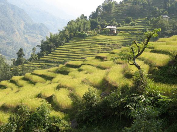
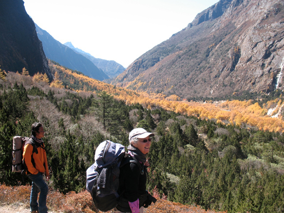
Walk east up road to left of airstrip keeping left and continue up to Deurali (2578m, Deurali Bhanjyang, deurali and bhanjyang both mean pass or saddle!) with excellent views from Mts Jannu to Kabru. Take the right fork when a road veers left to the pilgrim-magnet Pathibhara Devi Temple (3794m), a day’s walk away. There are very few vehicles on road after this junction. Stay on the rhododendron-covered ridge to Lali Kharka (2266m) where excellent classic dalbhat may be obtained and there are two lodges. Strong smell of honey, sound of cidadas and running water. Descend and circle through scrubby forest, watching out for shortcuts (chota bhatto) to Tembewa (1835m) after 1hr, then through the scattered houses of Simbu (1845m, Simbuwa), also great for lunch. In 2012 the **Aadamba Hotel with 4 beds and more being added was welcoming (Rs300, db Rs300) and served an unusual breakfast khaja (khaana jaane) of barley pancake with omlet. Or continue down a hot steep path, cross the Phawa Khola (1430m) and up steeply to the scattered bamboo and bananas hamlet of Kunjari (1800m). In 2023 all lodges were taken by Nepalis visiting for tihar so we continued for a total of 10hrs for the day to Kande Bhanjyang (2129m) with several good hotels and an astonishing range of vegetables in the dalbhat. The village lights were like constellations over the silent hills at night but the roosters start at 3am.
After Tembewa, walking from Suketar to Khunjari, view south
2. Kunjari to Phumphe Danda 750m↑ 700m↓ 7hrs
A steepish climb on steps 1.5hrs to Gurung Kande Bhanjyang (2130m, Sinchebu, Sinchewa Bhanjyang) with a friendly 5-bed inn and others. Enjoy the views of Kangchenjunga and a forest walk on steps down through hot and steamy but very prosperous hamlets growing millet, maize and rice to Delok (upper) Khesewa (2125m) for lunch. Drop steeply to a lovely waterfall and make a long climbing traverse, around a ridge and another long traverse lined with clear small waterfalls, to an endless flight of stairs and down to the neat houses of Phungphung Danda (1794m; danda means ridge), where we had lunch in 2023. Or continue another 1hr onto road and 400m up to Pumphe Danda 1858m. Fresh red cardamom (elanchai) is harvested at this season from the ginger-like plants under shade trees, at the risk of snake-bite to the labourers - we saw two dead krait. The roadside firepits covered with bamboo matting are to dry the cardamom and make black cardamom. Very settled and rich countryside that exudes contentment. We again very much enjoyed the **Phumphe Danda Teahouse (Rs400, db Rs350), with 4 beds in 2 rooms +977.9742625486, 024.680504 run by the late Gopi Bhattarai's wife. The golbheeda (tamarillo) pickle was a winner and the dahi (yoghurt) was excellent. There is another lodge lower down.
3. Phumphe Danda to Sherpagaon 480m↑ 270m↓ 6-7hrs
Down road 30mins through a cardamom plantation to a high bridge, where the current jeep road ends and then a gentle climb to the pretty and neat Limbu Mamankhe (1780m) where there are several lodges and a school. Tea with real milk but no coffee. There is one steep climb afterwards in hot steamy conditions with beautiful small waterfalls, purple orchids and some welcome deep forest. We found lunch with a lovely tomato achar in a farmhouse at Sisuwa, 2hrs after Mamankhe.
The high route after Mamankhe to 'Yamphudin', still shown on some maps, is closed as there have been several serious accidents and helicopter rescues from it. The map shows a descent to the Kabeli khola, then there is some road walking until you regain the old trekking trail and head up to Sherpagaon, confusingly shown as Yamphudin on many maps: Yamphudin is a lower village that you needn't visit, on the Kabeli khola and now serviced by a road from Phiddim and marked by hydro construction; the upper village left with many good lodges is properly called Sherpagaon (2080m). We stayed in the comfortable **Tashi Dele Snow Home, owned by the Sherpa whom we had met at Ramchaur before, with the tastiest bentah achar made of tamarillo, chilli, garlic, salt and ginger. There are several other good lodges.
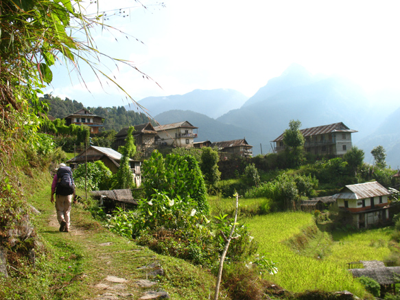
The pretty village of Mamankhe, looking north
4. Yamphudin to Torongden 1400m↑ 500m↓8-9hrs
This can be a long day. It may be possible to overnight in the bhatti on Lasiya Bhanjyang on benches around the walls of the single room, which is currently the poorest accommodation on the described trek, but the proprietor Lakpa and his wife are cheerful and friendly and the location beautiful. Before leaving, check with your hotel whether the Lasiya Bhanjyang bhatti is open – if it is not, then you will need to continue down another 2-3hrs to Tortong.There is also an alternative, with a lodge, described below. The map is very confusing and probably wrong on this day.
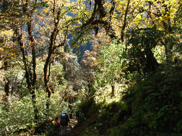
An early start makes the first climb, some in shade, less hot. Cross two tributaries of the large Amji Khola through ancient rhododendrons on a muddy track and at a junction just after the second (2hrs) climb north to Dhupi Bhanjyang (2540m) and enjoy the forest views. It is an unrelenting but pretty climb on good steps past a wooden seat chautaara, through a pasture marked as Chitre (2925m).Continue climbing on a stepped track in good condition through ancient rhododendrons to the welcome bhatti on Lasiya Bhanjyang (3310m; Lassi or Lamite Bhanjyang) with no toilet. If you choose to stay overnight here you can climb through silver pines up the hill behind the bhatti for extensive views of your onward route. We were in streaming cloud among the ancient rhododendrons and autumnal oaks the whole time when we stayed here in 2012. In 2023, a sudden sago snow storm decided us to sleep in the bhatti again. The brown fingers hanging in the roof are dried yak cheese made here, a delicacy called chhurpi.
Drop to the grassy pass overlooking an immense landslip with a view of Mt Jannu (7711m, Kumbakarna) to the northeast, then climb about 150m above it and descend on a muddy zigzag through lovely ancient forest with broadleaf sycamore and oaks turning yellow, blue spruce, and the deciduous larch, a feature of the Kanchenjunga area, starting to turn in late October to early November. The long-leaf rhododendrons are called chimal. Cross the Simbuwa Khola and make a short climb to Torongden (3000m, Torontan, Tortang) consisting of several busy lodges with separate rooms, well-stocked shops with Snickers and Mars (the first since leaving Suketar) and even electricity. In common with most places on the south side of Kanchenjunga, the dalbhat was superb. These lodges may be open from September-November and often February then March-May inclusive although if demand increases so too may the length of the season. The alternate entry for the south base camp arrives from Hellok here.
An alternative to the above described route is now reported, although we have not confirmed it: after the second bridge above Sherpagaon, instead of turning left, a sign points right to a Two Brothers lodge some 3hrs away. If reports are correct, there are three rooms on a pass northeast of Lasiya Bhanjyang, with a direct track down to Torongden afterwards. There is certainly a good track arriving from the right just before the Simbuwa khola bridge into Torongden. If correct, this would provide a shorter day and avoid staying in Torongden which can be fully occupied at times.
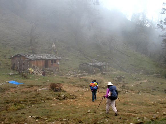
Arriving in Lasiya Bhanjyang, accommodation bhatti on left
Old forest below Lasiya Bhanjyang, dropping to Torontan
5. Torongden to Cheram 900m↑ 4-5hrs
Most people can climb to 3000m without getting altitude sickness, but the altitude gain in these track notes above Torongden is triple the 300m per day suggested for safety. Watch for signs of altitude sickness and be prepared to rest or retreat if they emerge. Consider using Diamox and remember that there are no clinics or easy communications in case of trouble.
From here there is about 900m of ascent beside the river, a long way and tiring but one of the most beautiful walks we have seen in Nepal: the changing sounds of the river, moss-hung forests with giant junipers and larches giving way to a huge range of rhododendrons, all mixed with various broadleafs turning with autumn. In warm sun with a following breeze there are few better places to be. Watch out for the grazing yaks, some are frisky.
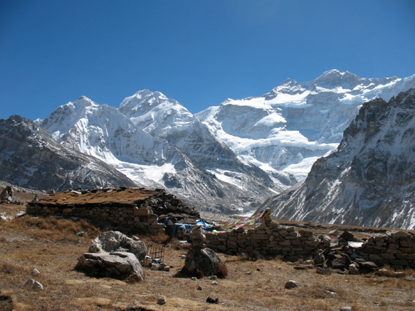
About 2hr finds a yak kharka with a decrepit shelter. We spent a memorable night among yaks there in 2013 as Torongden was closed for the season. After another 40mins there is a basic but very friendly lodge at Anda Phedi (3370m), not always open, where we stayed in 2023 as Torongden was full. No toilet. Yaks from Yamphudin are taken for grazing by the track that heads up to Anda Pokhari from here. After 30-45mins there is a beflagged and be-tridented Buddhist shrine to Susya, one of the original seven Tibetan goddesses, with a snake shape in the rock, north of which there is supposed to be a prohibition on the killing of animals but there was maasu (meat) on the menu in Cheram (3868m; Tseram), a crossroads for those coming over from the north side of Kanchenjunga. In November 2012, there were two lodges open with 6-7 rooms and another big new lodge not yet open, plus about 100 people in four separate tent encampments; in 2013 early December we were the sole inhabitants; but in November 2023 there were many more lodges. In 2012 we chose the **Yalungkhang Guest House, in 2013 late in the season we were grateful to find that Da Chiring (+977.993242131 in Yamphudin) had kept open his comfortable and now expanded **Blue Sheep Guesthouse (Rs500, db Rs 350), open March-May and September-November inclusive. In 2023 we enjoyed the hospitality and excellent food of **Kyabru View (6 rooms, Rs500, db Rs500) at the top of the village. There is battery electricity and well-stocked shops.
6. Cheram acclimatisation day 530m↑↓(5hrs)
We chose to take rest day in Cheram due to the altitude gain the previous day. We walked towards Ramchaur, through enchanted juniper groves, mossy rocks and clear water to open moraine ablation terraces lit with autumnal reds and browns to a lake with marvellous mountain views and back again in an easy 5hrs and could easily have gone to Ramchaur. 16km on a rest day! You could also climb directly above Cheram, or just rest and wash clothes. An up-valley wind with cold cloud can be a feature of this area later in each day.
7. Cheram to Ramchaur 750m↑ 3-4hrs
Ramchaur is getting crowded in season and has limited rooms plus 10 on the floor in the dining room despite being expanded; ask ahead if you plan to stay but whatever you do don’t miss going up there, even for a round day walk which can be easily done in 5hrs. A plastic dining area has improved it considerably.
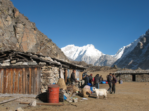
Head up through moss-hung pines and rhododendrons with a small clear stream, climb and cross a large loose gully and climb again into the seasonal yak pasture (kharka) at Yalung (wrong 3900m on map, probably 4100m). The Decherol Monastery with 6 monks, mentioned by Chandra Das in 1881, was located here but no trace remains of it or the surrounding village although a shrine is rumoured above. There follows a beautiful series of open ablation valleys, juniper, cinnamon-scented dwarf rhododendrons and moraines and lakes with the Sikkim border Kabrus, Rathong and Kokthang hanging above. Herds of blue sheep are often seen on the slopes to the left. Care will be needed crossing the many frozen streams and seeps. Watch out for yaks, some are totally wild, and for herds of blue sheep. The hidden stone lodge of Ramchaur (4580m; Ramche) is beautifully located and open March-May and September-November but ask in Cheram first at each end of these seasons. There is a reasonable shop (muesli, dried milk, Snickers/Mars). The food was excellent and the proprietor Pasang Sherpa very friendly (bed Rs750, db Rs600). Climb the nearby moraine wall for Yalung Glacier and mountain views and watch for snow pigeons and some of the seven varieties of lammergeiers or bearded vultures found in Nepal. In 2012 a flock of 30 blue sheep came right to the kitchen that night for the salt found in urine from the ‘open toilet’ and the kitchen slops - there is now a toilet. In 2012 it snowed heavily, complete with thunder, lightning, and drifts into the room through the wooden shutters. The lodge was closed in early December 2013 but open November 2023.
View down valley from above Cheram
Arriving at the lodge in Ramchaur, Rathong (R) and Kabru Ridge (L)
8. Ramchaur to Okhordung to Cheram 150m↑ 860m↓ 5-6hrs
Leave your rucksack behind but take a daypack with warm and windproof clothes for the upward leg, an easy gentle climb to a flagged cairn on a high moraine wall with views of the Yalung Glacier and the south face of Kangchenjunga, quite shapeless and foreshortened but undeniably massive. Okhordung (4730m, Oktang) is regarded as the base camp but the actual camp is another 2km/1hr/100m up on a track collapsing due to glacial retreat. We did not regard the extra views as worth the effort, but if you do add 2hrs to the day. Okhordung is certainly worth an hour or so soaking it up (snow pigeons!) then it takes about 1hr back to Ramchaur for lunch. Pick up your bag and enjoy going downhill to civilisation at Cheram again.
South face of Kangchenjunga from Okhordung (4740m)
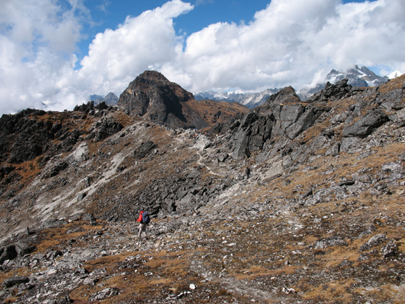
9. Cheram to Selele camp 1100m↑ 850m↓ 7-8hrs
This day and the next connect the south side of Kangchenjunga to the north side via a superb traverse smelling overwhelmingly, at altitude in autumn, of the honey-cinnamon of dwarf rhododendron. The traverse is remote and exposed to weather so consider a rest day in Cheram if the weather may spoil the views.
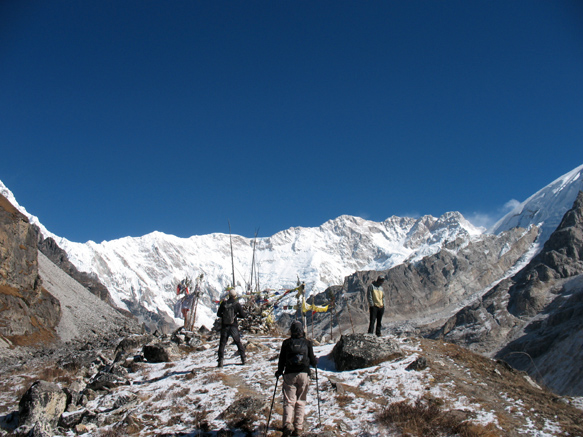
The 800m climb above Cheram has a reputation for steepness gained from those who have descended it. It is steep but firm underfoot and soon overcome. Climb to Sele La (4720m, not shown on map, sometimes called Sine Lapcha) in about 2.5hrs past two frozen tarns, the first with a seasonal bhatti, and one large cairn without flags. Descend a little and traverse right, gently up and down in lovely high pastures and scree with views as far as Makalu and even Everest. After about 1hr, pass a left-descending track to the turquoise lakes of Anda Pokhari and further down to Anda Phedi. Near here you may be able to refill your waterbottle from the only flowing stream we saw. A short climb takes you to prayer flags and a stone heap on a distinct pass that people from Ghunsa call the Misisay La (4645m, Sinelapche Bhanjyang on some maps) after the death 20 years ago of a Tibetan and two yaks at this point.
Continue traversing, noting the striking Lion Rock (singha dhunga) on the ridge above, and reach the windy and prayerflag-strewn notch Mirgin La (4645m, sometimes called Mirge La) after about 1.5hrs, from which the views of Jannu are as good as any available, together with Makalu, the long ridge of Chamlang and even a glimpse of Everest. Drop steeply into a boulder-choked valley with underground flowing water, eventually arriving in a classic cwm with the Selele Khola flowing crystal clear though the middle. Selele camp (4200m, Mani Bhuk) now has two lodges, usually open September-November and March-May inclusive. The first you reach is **Hillside Lodge (7 rooms, insulated but drafty, toilet, heated dining room, +977 9840616853
The naming of passes on the traverse from the sides of Kangchenjunga appears to depend on whether people come from Sherpagaon or Ghunsa, not helped by the fact the historical names were sometimes wildly applied to totally wrong places (eg Hooker referred to Mirgin La as Choonjerma Pass, which actually goes into Tibet above Olangchunggola). We think we have sorted them out so email if you want details. Note that la, deurali and bhanjyang all mean pass or saddle in broad terms.
View upvalley of Cheram, from Sele La (4720m). Rathong and Kabru ridge at back.
Approaching Mirgin La (4645m) from the south
Hillside Lodge at Selele camp 4200m, no camping required 2023
10. Selele camp to Ghunsa 100m↑ 800m↓ 4-5hrs
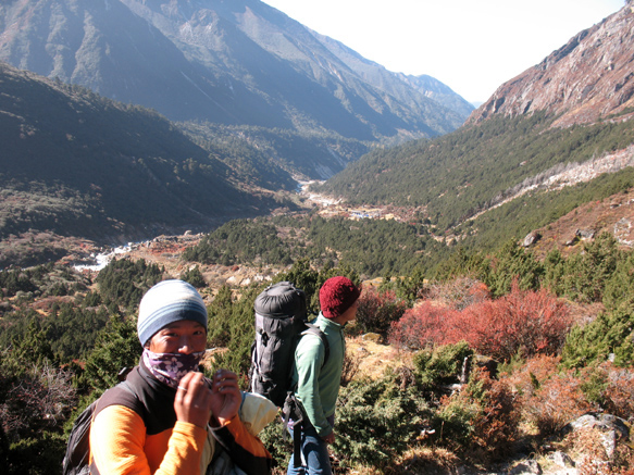
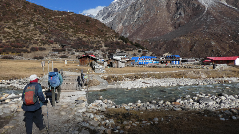
The sun doesn’t arrive until late, but it is short day and one of the loveliest walks in Nepal, so a late start is not an issue. Continue the northern traverse on a narrow rocky track to Selele La (4200m) with cairns and flags, continue circling with views down the Selele Khola, up to rocky peaks and rockfalls, across the valley to the Nango (Nangba) La (4795m) which can be used to access Olangchunggola and remote regions northwards. There is now a good seasonal bhatti with dalbhat before the descent. Eventually there is a chorten and prayer flags named Tama La locally that mark the start of a steeper descent through old-growth rhododendrons, silver birch, juniper and larches, past in small hydro station to Ghunsa (3595m), a large clean village of traditional wooden and new blue-roofed houses. In 2012 we chose **Peaceful Guesthouse with a lovely family and a warm bucket shower. In 2013 and 2023 we stayed at the expanded **Kangchenjunga Guesthouse (Western toilet, hot shower, washing machine service! dbl Rs1000, db Rs500) and were made very welcome by Himalichunda who helped tag the first snow leopard in Nepal, up at Kambachen. There are many lodges, one intriguing one with double-glazing, insulation, solar hot shower and en-suite toilet and even coffee and excellent cake, the Dzonga Family House run by Tashi Sherpa +977 9869317616
In 2012 and 2023 we took a rest day here the next day to wash clothes. The sun arrives very late at this time of year and the temperature rarely got above -10°C.
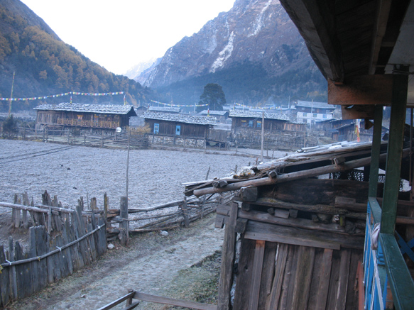
Houses in Ghunsa, looking over main street
11. Ghunsa to Khangpachen 650m↑ 100m↓ 4-5hrs
Most people can climb to 3000m without getting altitude sickness, but the altitude gain this day is over double the 300m per day suggested for safety. Watch for signs of altitude sickness and be prepared to rest or retreat if they emerge. Consider using Diamox and remember that there are no clinics or easy communications in case of trouble. If you take a rest day in Khangpachen, there is a lovely side trip closer to Jannu described in north-to-south.
Take the obvious track up through Ghunsa and cross a bridge, icy in the mornings. The autumn larches above are like sunlight along the Ghunsa Khola in October-November, one of the highlights of many visits to Nepal. Gentle pleasant walking, with some recent washaways, through larch, rhododendron, hemlock, pine and juniper forest, yaks coming down loaded with potatoes and the valley ahead blocked by the huge Jannu terminal moraine. After 2.5-3hrs arrive at Labuk (3960m) with two bhattis for lunch. The bridge that was here is gone and the dangerous slip avoided - stay on true left of the Ghunsa khola, circle and climb steeply on new steps, descend to new swing bridge with the gompa visible above the expanded and colourful Khangpachen (4080m; Kambachen).The **Kangchenjunga White House run by welcoming Nupu Sherpa (+977 9849190212
In 2013 we were privileged to arrive 2hrs after the first Nepal capture and collaring of a snow leopard, just above the hotel, and two days later glimpsed a female snow leopard in the same place. The World Wildlife Fund scientists told us there are about 18 snow leopards in the valleys above Khangpachen, feeding on the numerous blue sheep. Tibetan wolves however are starting to arrive too.
If you have time for a daywalk or need more acclimatisation, there is a stunning viewpoint for Mt Jannu (Khumbukarna 7714m) back across the swing bridge and zigzag about 2hrs up, with an important Kirat (Hindu) temple another 1hr up as well. BUT BEWARE: we met people who had continued further on to the Jannu base camp and so exhausted themselves that they turned back rather than continue up to Lhonak and Kangchenjunga north base camp. The viewpoint is far enough.
View downvalley from above Ghunsa with autumnal larches
Approaching much expanded Khangpachen 4080m from south in 2023
12. Khangpachen to Lhonak 750m↑ 100m↓ 4-5hrs
Again this is double the 300m per day altitude gain suggested for safety. Watch for signs of altitude sickness and be prepared to rest or retreat if they emerge.
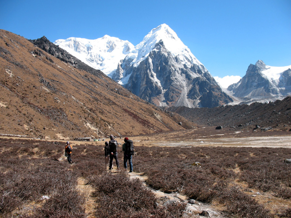
Climb past the chortens above Khangpachen then steadily on the true right bank with beautiful icy rocky peaks all around, though big areas of sea-buckthorn that fruit prolifically in October but are not harvested locally. We sighted several large flocks of blue sheep on the northwest valley wall. At times there may be avalanche snow across the track that can make crossing streams problematic and snow can make the going icy at the finish. After about 3hrs there is a welcome seasonal bhatti at Ramtang (4370m) for lunch (db Rs1500!) where you can smell the acrid burning yak dung, enjoy the ringing silence except for flocks of choughs, and eye-climb nameless icy peaks. A distinctive pillar up-valley on the right, owl rock (ullu dhunga), marks Lhonak's location. The last 30mins traverse a loose and exposed gully wall at length, cross a cantilever bridge and then a sandy plain to the many scattered huts of Lhonak (4780m). This is a very atmospheric place, mountain walls about a plain of yaks, now with several lodges. We stayed in **Lhonak Guesthouse with welcoming Chhirrup Lama (toilet inside lodge, exceptional dalbhat, double Rs1200, db 850) whose wife had seen a snow leopard just outside the night before. Walk up towards the Lhonak Glacier for the afternoon but take your warm clothes. Trekkers reported -24°C and -17°C at Lhonak but they were in tents and we found it to be no colder than -12°C.
Looking east from Lhonak (4792m) at Nepal Peak (7177m) - Kangchenjunga north face around the corner to right
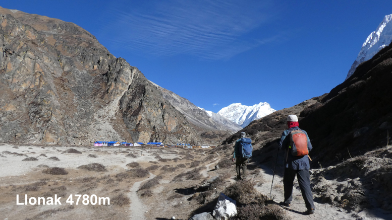
Many more lodges in lovely Llonak 4870m in 2023
13. Lhonak to Pang Pema to Lhonak 380m↑ 380m↓ 6-7hrs
This day takes you deep into the mountains with time to enjoy and acclimatize but glacial retreat is collapsing the moraine terraces, meaning that some sections require considerable care and there is an ever-present risk of stonefall. The walk takes about 2-3hrs more in 2023 than in 2013 and locals expect that it will not be passable within 10 years due to climate change. About two-thirds of the walk is on grassy terraces. The views of Kangchenjunga and the glacier are stupendous. We have seen Himalayan pika (rock rabbits), huge lammergeiers (bearded vultures), a big covey of chukar (Himalayan snow partridge), and many blue sheep. A seasonal bhatti after 2.5hrs at Ramdang (5050m), after the major slips, is very welcome. There is a single hut in Pang Pema (5140m) which is open from September but closed by mid-November (in 2013 and 2023) and in April to May and sometimes March and serves noodles for lunch (Rs500). A limited number of people could sleep inside but the altitude may make for a restless night. Pang Pema is generally regarded as the north base camp since it provides a complete view of the north face of Kangchenjunga. It has probably become impossible to go further given deteriorating moraine walls with climate change – probably better to spend the time climbing the rocky ridge above Pang Pema for wider and wider views if you have the energy. Retrace your steps for a second night in Lhonak, usually into the up-valley wind after 10am.
North face of Kangchenjunga from Pang Pema (5140m)
14. Lhonak to Ghunsa 200m↑ 1600m↓7-8hrs
Very charming walk with full valley views of the golden larches in season. Retrace your steps down-valley to Khangpachen in 3-4hrs cautious on the icy bits. Lunch is available, then on to Ghunsa in another 3-4hrs, taking care of your knees - it is a big descent in one day. The smell and sights of the forest are enchanting after the barren uplands. We actually choose to spend two days on this lovely section on an easy track through barberries and colourful sub-alpine scrub into hemlock, juniper, larch and rhododendron forest, seeing coveys of chilime blood pheasants, but most people rush down. At sowing and harvest, monks are invited into homes to chant the entire 1200 pages of Buddhist scripture in one day, from first light to dark - we were privileged to hear this on our return to Ghunsa so spent an extra day, and heard it again in Phale the next day.
15. Ghunsa to Amjilesa 400m↑ 1400m↓ 7-8hrs
Cross the Ghunsa Khola on a swing bridge near the Yak Hotel, turn left, pass the ancient Tashi Choding Gumba (which welcomes visitors but is usually locked) and climb to a memorial to the many wildlife people killed in an horrific helicopter crash near Ghunsa in 2006. Look up right at the next bridge to the route to a yak hut just under Nango La (4795m), by which it is possible to reach the ancient village of Olangchunggola (3191m, also Olangchun Gola "wolf leather enterprise") in two days. Some remote areas to the north of this pass beg for exploration if camping. Olangchunggola is reputed to be the original village settled from Tibet more than 600 years ago and there is now at least one lodge - see more in these tracknotes https://fedup.com.au/nepal/nepal-kangchenjunga-to-makalu-track-notes. Descend through the Tibetan refugee village of Phale (3215m, Falay, Phole) after 1hr. This atmospheric village offers a glimpse of authentic Tibetan culture with two active gompas, carpet-weaving and traditional lifestyle. If the gompa gate is open, check inside! In 2013 coming up-valley we stayed at the friendly **Kangchenjunga Folay Hotel (Rs500, db Rs300) and there are at least two other good homestays with private rooms. People were very welcoming. In 2023 we had a truly memorable lunch dalbhat at Llasa Guesthouse (5 rooms, +977 9849098057).
It is pleasant day dominated by the awesome river and beautiful juniper and hemlock, blue spruce, rhododendrons and autumn larches. Down on the river there is seasonal bhatti for lunch about 3hrs from Ghunsa. Two short steep climbs separated by a bridge bring you to Gyabla (2725m, Gyabru). We chose to slow down and stay in the large modern **Shingi Namjong Hotel (dbl Rs1000, db Rs350). There are two others, including chalets about 10min before the village.
Make a very messy steep descent into thick bamboo forest, dark as night but reputed to harbour red pandas. Black bears have been sighted in broad daylight across the river. The stony track goes up and down in bamboo until a small lodge at Thangyam (2405m) after 2hrs - a quality stone track was meant to sidle the awesome Ghunsa khola gorge direct to this lodge, but Amjilesa lodge-owners vetoed it, so you will have a relentless 200m climb from here and an equal descent tomorrow. Traverse on a narrow exposed track until finally Amjilesa (2400m, Amjillosa) is sighted and make a steady hot descent. There are two lodges with views vertiginously down to the Ghunsa khola roaring below. Both are good (dbl Rs 600, db Rs400). A common vegetable on both sides of Kangchenjunga at this altitude is the tutsi karela, a sort of small bitter gourd that grows on vines and features in most meals.
16. Amjilesa to Thiwa 200m↑ 1400m↓ 7-8hrs
A beautiful day’s walking with many bridges. The track is close to the Ghunsa Khola and is being steadily improved with newly-laid slabs in good order. Drop 380m in the first hour, cross a bridge to the true left at Phedi bhatti (phedi means foot of climb) and at a big cave look across the river to see monkeys. After another hour reach Lema Tar (1500m, lodge) for lunch/snack. Shortly thereafter cross to the true right on a new bridge. Eventually cross a new bridge to the true left again, pass a slip and cross again to the true right. After 30mins arrive at the roadhead at the large Sekathum Guesthouse above the invisible Shekathum (1576m, Sekathum) for lunch. A jeep can be obtained here although we saw none in 2023. It is possible also to climb to Lelep (2750m) which is headquarters for the Kanchenjunga Conservation Area with a pleasant courtyard and excellent dalbhat at the **Lelep Guesthouse. This is the access route for Olangchunggola and GHT to Makalu, where the Tamor Nadi (nadi is river) subsumes the Ghunsa khola.
As noted above, trekkers choosing to approach the south base camp direct from Taplejung head east from here, going from nearby Hellok or Ranipul to Yasang up the Sinuwa khola (3h, small lodge), then Yasang to Tortang (Torongden 2985m, 5h, many lodges).
There are a lot of child porters on this section, with some as young as 12 years old carrying up to 50kg. In 2013 they were paid about Rs2000 per day and have expenses of about Rs600-700, so earn about Rs1400 in a region where a good daily wage is Rs400.
The stepped trail onwards climbs up to rejoin the trail from Lelep. A broad stone path eventually drops to a flat and beautiful walk through rice, millet and buckwheat fields interspersed with cardamom plantations. Much of the track is in welcome shade. Cross to the true left at Tapethok (1322m), no longer a Kangchenjunga Conservation Area checkpost. Turn right and sidle the river. We found a pleasant lodge in Pipalbot after about 6hrs walking for the day, with views of millet fields and old-style farmhouses and enjoyed fresh dahi (yoghurt) with our dalbhats. Or in 30mins suddenly arrive in busy civilised Thiwa (1185m, Chiruwa ‘corner’) with pretty thatched houses, well-stocked shops and ISD/STD phones. **Hotel Tamang (Rs500, db Rs250) and **Hotel Kangchenjunga vie for your custom opposite each other, with verandahs overlooking the main track.
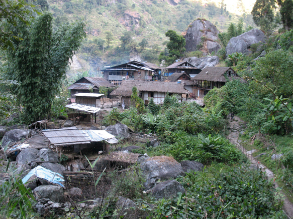
The cheery village of Thiwa (1185m), one or two days walk from Suketar
17-18. Thiwa to Taplejung 7-9hrs
There are two main alternatives from here in one or two days. A high route direct to Suketar, or via Mitlung to Taplejung.
Option 1: Walk south below Thiwa for 45mins to a swing bridge and immediately afterwards you can turn off the main trail and take a high route direct to Suketar on various roads. Lingkhim (1460m; Lingkham) is reached after only 3.5hrs but is easy to miss as it is a spread-out hamlet. A school above the road is the sign you have arrived, with the sole guest house a little further on. This is on the outside of a zigzag, so if you shortcut that particular zigzag then you will miss it. There are various other lodges now along this route. Follow the tractor road and arrive in Mayam (2000m) where you may score noodle soup. Afterwards, cross a swing bridge below the road and, taking numerous shortcuts steeply up to avoid zigzags, reach another new road and shops on a pass. From here, follow the road direct to Suketar (2420m) in about 2.5hrs, circling and descending in the last stages. You can see Taplejung ahead and below. Jeeps may offer you a dusty ride.
Option 2: Walk south on the jeep road with occasional jeeps and bikes, arriving at Sinwa (980m, Siwan, Sinuwa) for lunch and there are several good lodges. Then continue long and increasingly hot past extensive hydro works into Mitlung (921m), no longer rural but now a roadside stop for trucks. There are several lodges here. The next day regains the old trekking trail shortcutting road loops and climbing in 3-4 hours to Taplejung. Having done both we think this is the best option. Leave Mitlung downriver on the main trail. Bypass an old sign (Taplejung) on your left, stay on the main trail then go left and soon start to climb steeply. After some time traverse a suspension bridge and continue to climb steeply past some houses and terraced fields. To avoid zigzags the trail makes a lot of shortcuts. Get to a tractor road at ~ 1400m. The grade lessens and soon Asahangpati (~1600m, 2 hrs) is reached where Dirk had the best lunch on this trek opposite the health post. Continue on the tractor road, pass through cardamom plantations and arrive after another hour at Taplejung (1870m). Buses leave from the other end of town (15 mins).
KANGCHENJUNGA NORTH THEN SOUTH - TRACKNOTES BELOW NOT UPDATED since 2013, SEE SOUTH THEN NORTH FOR LATEST INFO....
|
Stage
|
Hours:minutes |
Accommodation? |
|
1 Dobhan-Mitlung |
5:00 |
Yes |
|
Alternative 1A. Taplejung to Mitlung, |
2:30 |
Yes |
|
Alternative 1B. Suketar – Lingkhim - Thiwa |
7:30 |
Yes |
|
2 Mitlung-Sinwa |
1:45 |
Yes |
|
Sinwa-Thiwa |
3:15 |
Yes |
|
3 Thiwa-Lelep |
3:15 |
Yes |
|
Lelep-Amjilosa |
4:15 |
Yes |
|
4 Amjilosa-Gyabla |
3:15 |
Yes |
|
Gyabla-Phale |
2:50 |
Yes |
|
5 Phale-Ghunsa |
1:00 |
Yes |
|
6 Ghunsa-Khangpachen |
4:00 |
Yes |
|
7 Khangpachen-Lhonak |
4:00 |
Yes |
|
8 Lhonak-Pang Pema |
3:15 |
Maybe |
|
Pang Pema-Lhonak |
2:40 |
Yes |
|
9 Lhonak-Khangpachen |
2:25 |
Yes |
|
Khangpachen-Ghunsa |
3:30 |
Yes |
|
10 Ghunsa-Selele Camp |
3:30 |
Yes |
|
11 Selele Camp-Mirgin La |
1:30 |
No |
|
Mirgin La-Misisay La |
1:15 |
No |
|
Misisay La-Sele La |
1:00 |
No |
|
Sele La-Cheram |
1:30 |
Yes |
|
12 Cheram - Ramchaur |
2:40 |
Yes |
|
13 Ramchaur – Okhordung |
1:30 |
No |
|
Okhordung - Cheram |
3:00 |
Yes |
|
14 Cheram-Tortong |
3:00 |
Yes |
|
15 Tortong-Lasiya Bhanjyang |
3:00 |
Maybe |
|
Lasiya Bhanjyang-(junction) |
1:20 |
No |
|
(junction)-Sherpagaon OR |
2:10 |
Yes |
|
(junction)-Yamphudin |
3:30 |
Yes |
|
16 Sherpagaon-Mamanke |
3:40 |
Yes |
|
Mamanke-Phungphung Danda |
1:30 |
Yes |
|
17 Phungphung Danda-Khesewa |
3:45 |
Yes |
|
Khesewa-Kande Bhanjyang |
0:30 |
Yes |
|
Kande Bhanjyang-Kunjari |
1:00 |
Yes |
|
Kunjari-Simbu |
1:00 |
Yes |
|
18 Simbu-Lali Kharka |
2:00 |
Yes |
|
Lali Kharka-Deurali |
1:30 |
No |
|
Deurali-Suketar |
1:00 |
Yes |
1. Dobhan to Mitlung 300m↑ 100m↓ 5hrs
Cross the Tamor Nadi (Tamur River) on a swing bridge, immediately turn left on a tractor road then after 15-20mins drop to the river on an unlikely loose track to find paddy tracks up-river. Cross to bustling Handrung (700m) after 30mins.Those bales of cardamom the porters are carrying are worth about $US1000 each. An alternative is to stay on the true right from Dobhan to Handrung – there are footings in for a vehicle bridge and road construction has started on the true right. From Handrung, head up-river on a new road and after about 500m drop onto tiny paddy tracks for 2hrs through rice harvesting, threshing and haystack building at this season. Enter a horror stretch of jungly rockfall, the track scarcely visible in the tall grasses, very up and down and sometimes very muddy through cardamom plantations, emerging into rice paddies after 2hrs. Drop and climb steeply to a welcome house and from here it is less than 30mins to the quiet string of white and ochre Chhetri houses of Mitlung (900m) with a avenue of frangipani trees. Just before the village join a broad trail and turn left. The track from the right comes down from Taplejung. The very comfortable **Mitlung Guest House is run by an experienced guide (Krishna Shrestha 9814367998), at top of village on left (Rs500, db Rs300). Sleep well on white sheets to the sound of the Tamur Nadi.
Alternative 1A. Taplejung to Mitlung, 950m↓ 2.5hrs
Note that the track described here is not shown on the map.
If you arrive early in Taplejung you may walk down to Mitlung in the afternoon. If you start early in the morning it is also possible to walk to Thiwa in one day.
Start at the north eastern end of Taplejung and follow a tractor road through cardamom plantations to Asahangpati (~1550m, 45mins). Continue on the tractor road until a steep descent starts at ~1400m. The trail makes a lot of shortcuts to avoid zigzags and drops through terraced fields and scattered houses. Cross a suspension bridge and continue the steep descent to arrive at Mitlung, 1.5 hrs
Alternative 1B. Suketar – Lingkhim - Thiwa 1250m↓ 7.5hrs
After arriving in Taplejung take a jeep to Suketar and stay there for the night. **Hotel Everest View (Rs700, db Rs300) adjoins the airstrip. Follow the description of days 17 and 18 of the south-to-north text in reverse. You should get to Lingkhim in about 4 hrs and to Thiwa in another 3 hrs. This alternative saves you the lower trail from Mitlung to Thiwa, so the air will be less humid and the heat less oppressive. It is possible to walk from Suketar to Thiwa in one day.
2. Mitlung to Thiwa 500m↑ 200m↓ 5hrs
Follow road for 30mins then climb on steps over a bluff for 75mins, and down to busy Sinwa (1055m) with three lodges (Tamor Khola, Paudel, Sinwa). After a total of 3hrs we found an isolated farmhouse with views down the wild Tamor valley. Lunch included ginger dal, fat brown local rice and the inevitable saag. Continue up and down, up and down (this is Nepal!), heading for the obvious right hand skyline ridge, at the base of which lies the pretty thatched village set in a huge rockfall of Thiwa (1200m, Chirwa, Chiruwa ‘corner’) after 1.5hrs. 45mins before Thiwa is a swing bridge from whose southern end a track climbs to Lingkhim (1466m) and thence to Suketar (2420m) if you choose to exit this way. **Hotel Tamang (Rs500, db Rs250) and **Hotel Kangchenjunga vie for your custom opposite each other, with verandahs overlooking the main track.
3. Thiwa to Amjilosa 1400m↑ 200m↓ 7-8hrs
This is a day of bridges from large to very informal, with some steep up and down. After 15mins take the lower river track and after 1hr cross a wooden swing bridge on a side stream, then after another 1hr cross the Tamor Nadi to the true right on a swing bridge at Tapethok (1322m, Taplethok). There is checkpost for those entering but not for those leaving the area. The track for several hours is now on well-laid flagstones, walking through lovely cardamom groves in the early morning shade with the river roaring below as you climb over a bluff for 1hr. There’s a welcome teashop with bananas to reward you. Make a final short climb into Lelep (1650m) which is headquarters for the Kanchenjunga Conservation Area with a pleasant courtyard and excellent dalbhat at the Lelep Guesthouse. Continue through the houses and take the middle path in a bamboo grove to drop about 150m and cross the Tamor Nadi for the last time on a long swing bridge to Hotel Handurung in 15mins. The village of Sekathum (1650m) is to the left but not visible and the remote Tibetan village of Olangchunggola (Walungchungkhola) is further up the same valley. Rather than the final climb to Lelep you can bypass it and go direct to Hotel Handurung but may not find it open for lunch. 10mins further on there is another lodge.
From here upwards the track follows the Ghunsa Khola, draining from the Kangchenjunga and Kumbhakarna (Jannu) glaciers and the major tributary of the Tamor Nadi. Turn right onto a rough riverside track just after the hotel. After 15mins don’t take the wooden swing bridge but 10mins later take the metal swing bridge to the true left then 10mins later cross back to the true right. 15mins after the bridge climb up, still on flagstones, past bluffs where we sighted two musk deer right on the track. After 1hr, cross to the true left – we sighted monkeys on the true right above the bridge. There’s another 1hr of up and down including some exciting riverside trails and informal bridges before the last bridge of the day crosses to the true right and climbs steeply for 400m in 1hr, traversing right over several ridges to Amjilosa (2400m). The **lodge is the third building with comfortable 12 beds in 3 rooms and Tibetan hospitality (Rs800, db Rs300). It claims to be open year-round. A common vegetable on both sides of Kangchenjunga at this altitude is the tutsi karela, a sort of small bitter gourd that grows on vines and features in most meals.
4. Amjilosa to Phale 1200m↑ 400m↓ 6hrs
This is a day of waterfalls. Sidle the huge visible slip with some exposure and climb further to round a bluff, then descend up and down across rockfalls set in dense bamboo to arrive at a teahouse after 1.5hrs. Look out all day for the red pandas reputed to be in this area.
After 1hr cross a substantial wooden bridge near the third waterfall, 20mins to another wooden bridge and the fourth waterfall, then climb steeply 30mins in a nasty wet gully to arrive in Gyabla (2725m) with 9-bed lodge and expensive Rs500 dalbhat.
Descend to the roaring river confined by cliffs and continue up and down on a rocky path. Black bears have been sighted in broad daylight across the river. After about 2hrs arrive at a pleasant sandy beach then climb, cross a slip then an extensive slip and exit at the top of a third slip onto a terrace of yak pastures. It is a very pleasant walk through juniper and rhododendrons to the Tibetan refugee village of Phale (3125m) about 1hr above the beach. While it is only another hour to the food, shops and bathing delights of Ghunsa, this atmospheric village offers a glimpse of authentic Tibetan culture with two active gompas, carpet-weaving and traditional lifestyle. We stayed at the friendly **Kangchenjunga Folay Hotel (Rs500, db Rs300) and there are at least two other good homestays with private rooms. People were very welcoming. It is possible to continue to Ghunsa the next day early enough to do washing and take a rest day, particularly as the sun is in Ghunsa only from 10am-4pm, a much shorter day than in Phale. Many people in Ghunsa have a house in Phale for the winter.
5. Phale to Ghunsa 200m↑ 1hr
A very pleasant walk through pines, rhododendrons and the deciduous larches for which this area is famous, although most have lost their colour and needles by the end of November. Look up left after the next bridge to the route to a yak hut just under Nango La (4795m), by which it is possible to reach the ancient village of Olangchunggola (~3000m) in two days. This village is reputed to be the original village settled from Tibet more than 600 years ago but there is no accommodation at present. Later there is a memorial to the many wildlife people killed in an horrific helicopter crash near Ghunsa in 2006. Pass the ancient Tashi Choding Gumba (which welcomes visitors but is usually locked) before crossing a swing bridge into Ghunsa (3415m).
The Ghunsa houses are charming, with rocks holding down shingles on roofs, dark weathered pine walls, a forest of prayer flags and juniper burning in the morning. Yaks, dogs, goats and chickens roam the main street. Fresh milk and dahi (yoghurt) may be obtained in season. Ghunsa can be busy with people coming and going all the time, but in the last 10 days of walking in 2012 we met only 23 ‘teahouse trekkers’ in total, in 8 groups. There were also 6 large camping groups. In 2013, being later, we met only one German and five Russians although there had been many more just weeks earlier.
In order from the bottom of Ghunsa, there is the Snowline Lodge (R), Kangchenjunga Guest House (L), Selele Guest House (L), Sherpa Guest House (L), Ghunsa Guest House (L), Yak Hotel (L down lane), Peaceful Guesthouse (R), and another closed lodge (R). In 2012 we chose the **Peaceful Guesthouse (Rs250 single, Rs500 double/triple, db Rs400) with a lovely family and a warm bucket shower. In 2013 we stayed at the **Kangchenjunga Guesthouse (Rs500, db Rs500) and were very comfortable with a good toilet, shower, food and family. Phones are available, as well as reliable hydroelectricity and several well-stocked shops.
In 2012 we took a rest day here the next day to wash clothes, and by afternoon it was snowing.
6. Ghunsa to Khangpachen 850m↑ 100m↓ 4hrs
Most people can climb to 3000m without getting altitude sickness, but the altitude gain this day is double the 300m per day suggested for safety. Watch for signs of altitude sickness and be prepared to rest or retreat if they emerge. Consider using Diamox and remember that there are no clinics or easy communications in case of trouble. You may want to spend a rest day in Khangpachen - see side trip notes below.
Take the obvious track up through Ghunsa and cross a bridge, icy in the mornings. The autumn larches above are like sunlight along the Ghunsa Khola in October-November, one of the highlights of many visits to Nepal. Gentle pleasant walking through larch, rhododendron, silver pine and cedar forest, with yaks coming down loaded with potatoes and the valley ahead blocked by the huge Jannu terminal moraine. After 2.5-3hrs cross a cantilever bridge to the true right, circle two big slips with significant rockfall danger and striking views of Jannu (7711m, Kumbakarna) and climb steeply. Then stop and admire the best views of Jannu! Traverse and eventually cross a small stream into Khangpachen (4145m; Khambachen) with about 10 stone houses. The **Kangchenjunga White House run by welcoming Norbu Sherpa (Rs500 double, RS600 triple, db Rs595) has now 7 rooms with 16 beds, excellent food and is open September-October and maybe November depending on season, and April-May and maybe March depending on season. Call Norbu at +977.993242319 (Ghunsa) 993244578 or 993244579 (Khangpachen). Other places cater only to camping groups. The valley northwest up the Nupcha Khola calls out for an afternoon ramble.
In 2013 we were privileged to arrive 2hrs after the first Nepal capture and collaring of a snow leopard, just above the hotel, and two days later glimpsed a female snow leopard in the same place. The World Wildlife Fund scientists told us there are about 18 snow leopards in the valleys above Khangpachen, feeding on the numerous blue sheep.
An interesting side trip for a Khangpachen rest day will bring you closer to Jannu. Check in Khangpachen for the current location of a seasonal bridge over the Ghunsa Khola. Cross the meadow after the bridge and walk uphill on a trail to the northern side of the Kumbakharna (Jannu) Glacier. After about 2.5hrs reach a shrine (~ 4650m) marked by many prayer flags, bells, tridents, letters and other objects of worship. Rest and enjoy the view of Jannu and its neighbours. It is possible to continue for at least another hour but the ground is prone to landslides. Return to Khangpachen in about 2hrs. Elevation gain and loss is about 600m.
7. Khangpachen to Lhonak 750m↑ 100m↓ 4.5hrs
Again this is double the 300m per day altitude gain suggested for safety. Watch for signs of altitude sickness and be prepared to rest or retreat if they emerge.
Climb past the chortens above Khangpachen then steadily on the true right bank with beautiful icy rocky peaks all around, though big areas of sea-buckthorn that fruit prolifically in October but are not harvested locally. There are at least two large flocks of blue sheep. At times there may be avalanche snow across the track that can make crossing streams problematic and recent snow in 2013 made the going icy at the finish. The last 30mins traverses a loose and exposed gully wall at length, crosses a rude bridge and then a sandy plain to seven scattered huts of Lhonak (4792m). One hut has a triple bed room, and two dark twin bed rooms (Rs1000, db Rs700). This is a very atmospheric place, mountains walls about a plain of yaks, particularly at night when you seek the ‘open toilet’ – be careful what you shelter behind! Walk up towards the Lhonak Glacier for the afternoon but take your warm clothes. Visitors in the days before us in 2012 reported -24°C and -17°C at Lhonak but they were in tents and we found the hut at -4°C warm enough. 2013 was also very cold.
8. Lhonak to Pang Pema to Lhonak 350m↑ 350m↓ 6hrs
This day takes you deep into the mountains with time to enjoy and acclimatize but glacial retreat is collapsing the moraine terrace, meaning that some sections require considerable care and there is an ever-present risk of stonefall. About two-thirds of the walk is on grassy terraces. The views of Kangchenjunga and the glacier are stupendous. We also saw Himalayan pika (rock rabbits), a big covey of chukar (Himalayan snow partridge), and more blue sheep. There is a single hut in Pang Pema (5140m) which is open from September to sometimes mid-November and in April to May and sometimes March and serves noodles for lunch (Rs500). A limited number of people could sleep inside. We regret that we didn’t plan to spend a night here, although the altitude may make for a restless night. Pang Pema is generally regarded as the north base camp since it provides a complete view of the north face of Kangchenjunga, but it is possible to go further on deteriorating moraine walls – probably better to spend the time climbing the rocky ridge above Pang Pema for wider and wider views if you have the energy. Retrace your steps for a second night in Lhonak, usually into the up-valley wind after 10am.
9. Lhonak to Ghunsa 200m↑ 1600m↓ 7-8hrs
Very charming walk with full valley views of the golden larches in season. Retrace your steps down-valley to Khangpachen in 3-4hrs taking care on the icy bits. Lunch is available, then on to Ghunsa in another 3-4hrs, taking care on the two big slips which are now in the sun. The smell and sights of the forest are enchanting after the barren uplands. It is a 1600m descent today so watch your knees.
10. Ghunsa to Selele Camp 800m↑ 100m↓ 3.5-4hrs
This day and the next connect the north side of Kangchenjunga to the south side via a superb traverse smelling overwhelmingly, at altitude in autumn, of the honey-cinnamon of dwarf rhododendron. The traverse is remote and exposed to weather so consider a rest day in Ghunsa if the weather may spoil the views.
Climb past the hydroelectricity station below Ghunsa and cross the Yamatori Khola to a sunny meadow, on the other side of which the track climbs on a beautiful rhododendron ridge for 1.5-2hrs to a viewpoint (known locally as Tama La) of Phale, Nango (Nangba) La which leads to Olangchunggola, and the terminal moraine under Jannu. Leaving the trees, circle on a very rocky track with mounting views. After another 1.5-2hrs take the short steep climb to Selele La with its pile of stones and prayer flags. Lie in the sun and soak up the views, then in 30mins through rockfalls arrive in **Selele Camp (4130m, Mani Bhuk) with 4 rooms and a total of 12 beds and the clearest stream running through the rocks on the flat (Rs1000 db Rs600). There is still no toilet so be careful of surprises behind the many rocks. This is a profoundly beautiful place, particularly towards evening as the valley clouds rise from below. The camp had been closed towards the very end of November but we arranged for Pasang to come up from Ghunsa and open it for us and cook for a small extra fee. Usually it is open September-November and March-May inclusive. If near the start or end of the seasons, ring Dawa and Pasang Sherpa in Ghunsa +977.994232334 and check.
11. Selele Camp to Cheram 850↑ 1100m↓ 4.5-5.5hrs
The sun arrives about 8.30am in winter. Steady climbing up valley, largely through silent boulders with the stream deep in the rockfall and mounting views. Late snowfall can remain on north-facing slopes, making icy the ascent to the windy prayer flagged notch of Mirgin La (4645m) in about 1.5hrs. The views of Jannu from here are as good as any available, together with Makalu, the long ridge of Chamlang and even a glimpse of Everest. From here, traverse two obvious watersheds on fallen rock, up and down noting Lion Rock on the ridge above and finally climb to a second pass with flags and stones after 1hr 15mins. People from Ghunsa call this the Misisay La (4645m, Sinelapche Bhanjyang on map) after the death 20 years ago of a Tibetan and two yaks at this point. Just after this pass a track drops steeply right past two blue lakes (Anda Pokhari) to Anda Phedi where there is now a lodge. Near here you can refill your waterbottle from the only flowing stream we saw. Keep traversing left with growing views down valley where it is possible to make out the huge slip near Lasiya Bhanjyang. After 1hr a steep climb reaches the chorten and prayer flags of Sele La (4720m) and spectacular views of the Kabrus, Rathong, Kokthang, Khang La and the Yalung Glacier. The best view is 15 mins below the pass and also includes a part of Kangchenjunga.
Scramble down 30mins on loose rocks to a sacred lake then past a second sacred lake and a long long way down reach welcome Cheram (3868m, Tseram) in 1hr. Cheram is a crossroads with new lodges still being built. In 2012 there were two lodges open with 6-7 rooms and another big new lodge not yet open, plus about 100 people in four separate tent encampments. In 2012 we chose the **Yalungkhang Guest House (Rs250, db Rs450). There is electricity and there are well-stocked shops. In 2013 late in the season we were grateful to find that Da Chiring (+977.993242131 in Yamphudin) had kept open his comfortable **Blue Sheep Guesthouse (Rs500, db Rs 350) with 8 beds in 4 rooms, open March-May and September-November inclusive. In 2012 Cheram saw 250 teahouse trekkers; in 2013 400 teahouse trekkers total in both seasons.
The naming of passes on the traverse from the sides of Kangchenjunga appears to depend on whether people come from Yamphudin or Ghunsa, not helped by the fact the historical names were sometimes wildly applied to totally wrong places (eg Hooker referred to Mirgin La as Choonjerma Pass, which actually goes into Tibet above Olangchunggola). We think we have sorted them out so email if you want details. Note that la, deurali and bhanjyang all mean pass or saddle in broad terms.
12. Cheram to Ramchaur 750m↑ 2-3hrs
Ramchaur is getting crowded in season and has only 3 rooms with 2 beds in each plus 10 on the floor in the dining room; ask ahead if you plan to stay but whatever you do don’t miss going up there, even for a round day walk which can be easily done in 5hrs.
Head up through moss-hung pines and rhododendrons with a small clear stream, climb and cross a large loose gully and climb again into the seasonal yak pasture (kharka)at Yalung (wrong 3900m on map, probably 4100m). The Decherol Monastery with 6 monks, mentioned by Chandra Das in 1881, was located here but no trace remains of it or the surrounding village although a shrine is rumoured above. There follows a beautiful series of open ablation valleys, juniper, cinnamon-scented dwarf rhododendrons and moraines and lakes with the Kabrus, Rathong and Kokthang hanging above. Care will be needed crossing the many frozen streams and seeps. Watch out for yaks, some are totally wild, and for herds of blue sheep. The hidden stone lodge of Ramchaur (4610m; Ramche) is beautifully located and open March-May and September-November but ask in Cheram first at each end of these seasons. There is a reasonable shop (muesli, dried milk, Snickers/Mars). The food was excellent and the proprietor Pasang Sherpa very friendly (bed Rs300, db Rs500). Climb the nearby moraine wall for Yalung Glacier and mountain views and watch for snow pigeons. In 2012 a flock of 30 blue sheep came right to the kitchen that night for the salt found in urine from the ‘open toilet’ and the kitchen slops. It also snowed heavily, complete with thunder and lightning, and drifted into the room through the wooden shutters. The lodge was closed in early December 2013.
13. Ramchaur to Okhordung to Cheram 150m↑ 900m↓ 4-5hrs
Leave your rucksack behind but take a daypack with warm and windproof clothes for the upward leg, an easy gentle climb to a flagged cairn on a high moraine wall with views of the Yalung Glacier and the south face of Kangchenjunga, quite shapeless and foreshortened but undeniably massive. Okhordung (4740m, Oktang) is regarded as the base camp but the actual camp is another 2km/1hr/100m up on a track collapsing due to glacial retreat. We did not regard the extra views as worth the effort, but if you do add 2hrs to the day. Okhordung is certainly worth an hour or so soaking it up then it takes about 1hr back to Ramchaur. Pick up your bag and enjoy going downhill to civilisation at Cheram again.
14. Cheram to Tortong 900m↓ 3hrs
This descent by the Simbuwa Khola is one of the most beautiful walks we have seen in Nepal: the changing sounds of the river, a huge range of rhododendrons giving way to moss-hung forests with huge pines and larches, all mixed with various broadleafs turning with autumn is all very restful. In warm sun with a breeze there are few better places to be. Be careful of grazing yaks.
After 30mins there is a beflagged Buddhist and be-tridented Hindu shrine with a snake shape in the rock, north of which there is supposed to be a prohibition on the killing of animals but there was maasu (meat) on the menu in Cheram. After another 40mins there is a new basic lodge at Anda Phedi, but closed in December 2013. Yaks from Yamphudin are taken for grazing by the track that heads up to Anda Pokhari from here. Another 40mins finds a yak kharka where you might get a meal or tea. We spent a memorable night among yaks there in 2013 as Tortong was closed for the season. Tortong (2980m, Torontan), 1hr further down, consists of two good lodges with separate rooms, well-stocked shops with Snickers and Mars and even electricity. In common with most places on the south side of Kanchenjunga, the dalbhat was superb, albeit with unrequested lumps of fatty pork. These lodges may be open from September-November and sometimes February then March-May inclusive although if demand increases so too may the length of the season.
15. Tortong to Sherpagaon 1100m↑ 2100m↓ 7-8hrs
Cross the Simbuwa Khola on a bridge, traverse and climb through old forest for 1hr then start a steep ascent for 1.5hrs with zig-zags and considerable yak damage to the track as they have been taken to and from pasture. There is a huge unstable slip to the right that needs to be climbed 150m above before a bypass drops to the grassy Lasiya Bhanjyang (3415m; Lassi or Lamite Bhanjyang). 200m on is a bhatti in which you may be able to sleep on benches around the walls if it is open; the proprietor is cheerful and friendly and the location beautiful but it closes when water runs out. Climb through silver pines up the hill behind the bhatti for distant blue hills through ancient pines plus a view of Mt Jannu (7711m, Kumbhakarna) to the northeast. We were in streaming cloud among the ancient rhododendrons and autumnal oaks the whole time we were here in 2012 but it was closed in December 2013 as there was no water.
The track condition improves below as the yaks are taken another way, but the descending stepped track is endless and there is no water until Amji Khola. After about 1hr cross the open kharka of Chitre (2925m) then in 20mins there is a wooden seat chautaara at an important junction.
For Yamphudin, which is not visible from here, go down left to a small camping site called Omje Kharka in the valley, drop through ancient rhododendrons on a muddy track to a new swing bridge across the Amji Khola at 2340m, climb over the bare saddle called Dhupi Bhanjyang (~2500m) visible to the south then drop to Yamphudin (1692m) down on the Kabeli Khola.
For Sherpagaon, which you can see on the terrace to the south, go right and drop very steeply on a narrow trail to the Amji Khola at ~1500m through pretty autumn forests. After a welcome drink there is 1.5hrs of up and down, during which we saw two deer on the lonely track, to reach the pretty village of Sherpagaon (2000m, upper Yamphudin) with good views. The **Yamphudin Guesthouse (Rs400, db 350) has 5 rooms and 15 beds. +977.993244556; they run the Yalung Guesthouse in Cheram too. The alternative **Talung Guesthouse +977.993242124 at the other end of the village has a good reputation.
Sherpagaon does not appear on most maps and is sometimes called upper Yamphudin. Yamphudin (1692m) is 300m below and has several comfortable lodges. In 2012 we stayed in the friendly and helpful **Yellow lodge (Rs200 per bed, db Rs150 with the tastiest bentah achar made of tamarillo, chilli, garlic, salt and ginger). There is a TIMS and permit check here.
16. Sherpagaon to Phungphung Danda 650m↑ 800m↓ 4-5hrs
This day includes crossing a grassy cliff at length with an exposed narrow trail where a mis-step would be fatal. If this is a concern it is possible to go via Yamphudin and up the main trail.
Climb up past the Talung Guesthouse on a paddy trail to start a day of high traverses, dropping in and out of sharp valleys with waterfalls and forest and occasional houses. Yamphudin is visible below on the Kabeli Khola. A feature of the morning is a high, well-built but narrow track across a bare grassy and very steep face for 1hr. We found a delicious korella dalbhat lunch in a Limbu farmhouse just before joining the main track between Yamphudin and the pretty and neat Limbu village of Mamanke (1780m) which we reached after 1.5hrs. There are several teahouses with beds; tea with real milk but no coffee. Drop to a long suspension bridge over the Takshewa Khola and climb 300m to Phungphung Danda (1860m, Pumphe, Pumphe Danda) in about 1.5hrs. We very much enjoyed the **Phumphe Danda Teahouse (Rs400, db Rs350) with 4 beds in 2 rooms +977.9742625486, 024.680504 run by Gopi Bhattarai and his wife. The golbheeda (tamarillo) pickle was a winner and the dahi (yoghurt) was excellent. There is another lodge lower down. This is very settled and rich countryside that exudes contentment.
17. Phungphung Danda to Simbu 900m↑ 1100m↓ 6-7hrs
A pleasant day, cool in the shade with deep forests and lots of waterfalls. Climb on stairs with an excellent view of Jannu, make a long traverse and drop down to a welcome shady waterfall after about 3hrs. Climb more stairs for 400m 45mins for lunch on the lawn at Delok (upper) Khesewa (2125m). Fresh red cardamom (elanchai) is harvested at this season from the ginger-like plants under shade trees, at the risk of snake-bite to the labourers. Climb onwards over saddles through hot and steamy but very prosperous hamlets growing millet, maize and rice and traverse to Gurung Kande Bhanjyang (2130m, Sinchebu, Sinchewa Bhanjyang) with a 5-bed homestay in 30mins. Drop steeply to Kunjari (1800m) in 1hr where the lodge is adding two rooms which will improve overnights. Descend on an endless ridge, cross the Phewa Khola (1430m) and climb steeply to Simbu (1700m) in another 45mins. The **Aadamba Hotel with 4 beds and more being added was welcoming (Rs300, db Rs300) and served an unusual breakfast khaja (khaana jaane) of barley pancake with omlet. The village lights were like constellations over the silent hills at night but the roosters start at 3am.
18. Simbu to Suketar 1000m↑ 200m↓ 4-5hrs
Leave early to catch the cool as the trail is up on continuous stairs and awkward riprap, arriving at Lali Kharka (2266m) with a road now running through it after about 2hrs. More climbing on road and shortcuts to Deurali (2578m, Deurali Bhanjyang!) after 1.5hrs for an excellent classic dalbhat. The pilgrim-magnet Pathibhara Devi Temple (3794m) is a day’s walk to the right from here. Suketar (2420m), the runway clearly visible below, is a further 1hr on road and shortcuts to the left. **Hotel Everest View (Rs700, db Rs300) adjoins the airstrip.
See also a recent lovely collection of photos from Oleg Bartunov at http://www.flickr.com/photos/obartunov/sets/72157638505259604/
Sue and Howard Dengate (October-November 2012, November-December 2013, November 2023)
All changes, comment and corrections welcome at